
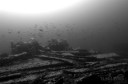
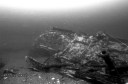
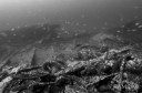
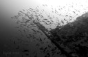
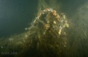
One of the things I love about diving in New Jersey is that it is exactly like a box of chocolates… you never know what you’re going to get. Heading down the line Saturday I was expecting the bottom conditions on the MOHAWK (80fsw), to not be any better than the pea soup near the surface. However once I hit about 40 feet it was like the bottom dropped out and I could see the wreck stretching off in the distance and huge schools of fish of several varieties, in the wonderful 40-50 feet of visibility. I was able to spy a good tie in and adjust my descent accordingly, which made my work much easier. For a second I had flashes of the Caribbean, and was totally unexpected for being only 6 miles off the beach. This is the best time of year to dive. It’s not hot, and the sub surface conditions are about as good as its gets. It was 64F from top to bottom.
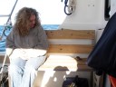
I had only been on the MOHAWK once before, and today gave me a chance to get a real lay of the land. The wreck is huge and I took a good hour going from the very stern where we were tied in to the bow and back just soaking it in. During the interval an exhausted sparrow took refuge on the bench, and kept us company. About 5 decent lobsters came up topping off a really great day to be out on the Atlantic!

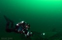


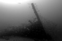

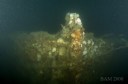
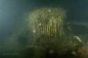
Sunday the Independence II headed to the AYURUOCA (aka Oil wreck). This 468′ frieghter sits in 175 fsw in the Mud Hole. It was cut in two in a collision with the GENERAL FLEISCHER during blacked out WWII operations. Among other cargo the AYURUOCA was carrying trucks to support the war effort which litter the main deck of the wreck. The stern and bow sections both sit upright and mostly intact but are separated by a 100 feet or so. The Mud Hole is a canyon cut from the surrounding sea bed by the Hudson River. It is very silty and conditions can be dubious at best, but we had high hopes that the conditions form Saturday would carry over. Danny and I were tieing in, and the surface and mid-water visibility was excellent. At about 70-80 feet we hit a strong current and the shot line was going horizontally through the water column (not a good sign). Suddenly the mast appeared out of the gloom and we knew we were at least on the wreck. As we dropped down it was apparent the shot had draped over the wreck. We finally found it snagged in the debris field where I registered 173 fsw. There was some confusion as we thought we were on the bow section but as Danny and I scanned for a good tie in spot, the bridge area didn’t look familar. The wreck is beginning to seriously collapse in on itself. Last year the top of the bridge was about 125 fsw. Now the highest point is the port railing at about 135-140 fsw and the entire bridge has collapsed with a severe list. Visbility was variable and it didn’t take much to stir up the silt. The flounder on deck getting scared off by divers didn’t help. But for the Mud Hole it was very nice and averaged about 15 feet. I didnt get a bottom temp but there was a thermocline around 100 feet above which it was 64 F. Can’t wait to get back!


Leave a comment